Analysis of Commercial Value Conversion of Changguang Satellite's Night Light Remote Sensing Technology Breakthrough
Unlock More Features
Login to access AI-powered analysis, deep research reports and more advanced features
About us: Ginlix AI is the AI Investment Copilot powered by real data, bridging advanced AI with professional financial databases to provide verifiable, truth-based answers. Please use the chat box below to ask any financial question.
Now I will provide you with a systematic and comprehensive analysis report based on the collected information.
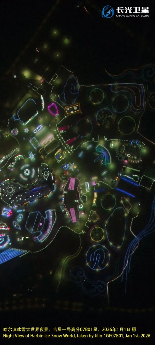
In January 2026, the “Jixing” Gaofen-07 series satellite developed by Changguang Satellite Technology Co., Ltd. successfully captured China’s first very-high-resolution color night light remote sensing satellite image using night light imaging mode. This breakthrough is a milestone achievement[1][2].
- Resolution Index: Very-high-resolution (better than 0.3m), representing the cutting-edge level in the current remote sensing field[3]
- Imaging Swath: 15km high spatial resolution night light push-broom image
- Positioning Accuracy: High uncontrolled positioning accuracy, enabling clear imaging of individual street lamp lighting areas
- Technical Path: Adopted decelerated push-broom under ultra-stable attitude control combined with long-exposure high-order time-delay integration technology, achieving a significant improvement in detection sensitivity[3]
This technology is another major breakthrough in the field of night light imaging following Changguang Satellite’s sub-meter level night light remote sensing technology services, laying a solid foundation for the subsequent operational services of high-resolution night light data[1].
By capturing artificial light sources on the earth’s surface at night, night light remote sensing technology can provide unique socio-economic and natural environment data, with extensive application scenarios and important value[1][2]. According to research by Academician Li Deren, night light remote sensing can be applied in the following fields:
| Application Field | Specific Scenarios | Commercial Value |
|---|---|---|
Economic Development Evaluation |
Urban GDP calculation, economic activity monitoring | Provides objective data support for government decision-making and enterprise investment |
Population Distribution Analysis |
Nighttime population density estimation, urbanization process monitoring | Supports urban planning, land use planning |
Energy Consumption Monitoring |
Real-time power energy consumption monitoring, power grid load assessment | Basis for energy enterprise optimization scheduling and carbon emission accounting |
Carbon Emission Estimation |
Spatial distribution of carbon emissions, inversion calculation | Supports monitoring and verification of the “Dual Carbon” goals |
Urban Expansion Monitoring |
Dynamic changes of urban boundaries, urban agglomeration development | Natural resource management, urban governance |
Nighttime Economy Monitoring |
Commercial district vitality, nighttime consumption hotspots | Commercial site selection, consumption trend analysis |
Emergency Rescue |
Nighttime disaster assessment, rescue dispatch | Rigid demand scenario for fire and emergency management departments |
Environmental Health Assessment |
Light pollution monitoring, ecological impact assessment | Monitoring demand for environmental protection departments |
Changguang Satellite’s very-high-resolution color night light technology has significant advantages compared to traditional night light remote sensing:
- Resolution Advantage: The 0.3m-level resolution is much higher than that of traditional night light satellites (e.g., approximately 500m resolution of NPP/VIIRS), enabling “point light source-level” observation
- Color Information: Color night light images provide richer information dimensions, allowing distinction between different types of light sources
- Localized Services: As the first domestic enterprise to achieve this technological breakthrough, it has inherent advantages in data security and policy compliance
- Constellation Synergy: Relying on the networking advantages of the “Jilin-1” satellite constellation, it can achieve high-frequency revisit services
This technological breakthrough of Changguang Satellite will significantly expand its serviceable market boundaries:
| Market Dimension | Traditional Optical Remote Sensing | Night Light Remote Sensing Increment |
|---|---|---|
| Service Objects | Surveying and mapping, natural resources, agriculture | Power, carbon emissions, urban management, commerce |
| Data Products | Basic images, thematic maps | Real-time monitoring data, economic indicator data |
| Business Model | Project-based, order-based | Data subscription, continuous monitoring services |
| Customer Stickiness | Low (one-time delivery) | High (continuous service relationship) |
The technological breakthrough will help Changguang Satellite expand its customer groups from the following dimensions:
- Expand from natural resources and surveying and mapping departments to ecological environment, development and reform, energy, housing and urban-rural developmentdepartments
- Supports “Dual Carbon” monitoring, smart city construction and other policy rigid demands
- Power grid companies: Power load monitoring, power grid planning optimization
- Commercial real estate: Commercial district vitality assessment, site selection analysis
- Insurance companies: Risk assessment (natural disasters, industrial safety)
- Financial institutions: Economic activity monitoring, investment area assessment
- Provide night light data services to countries along the “Belt and Road”
- Participate in international global change research projects
Changguang Satellite can develop the following product matrix based on the new technology:
| Product Tier | Product Type | Target Customers |
|---|---|---|
Basic Data Products |
High-resolution raw night light images | Research institutions, universities |
Standardized Products |
Night light index, economic vitality map, energy consumption heat map | Government decision-making departments |
Customized Services |
Regional monitoring reports, special analysis services | Large enterprises |
Platform Services |
API interfaces, data subscription platforms | Internet enterprises, developers |
Solutions |
Industry application systems (carbon monitoring, urban management) | Large government and enterprise customers |
According to public information, Changguang Satellite withdrew its Sci-Tech Innovation Board IPO application in 2024, with an original planned fundraising of RMB 2.683 billion[4]. The prospectus shows that the company was unprofitable and had accumulated deficits from 2019 to the first half of 2022, mainly due to:
- High satellite depreciation costs from the construction of the “Jilin-1” satellite constellation
- High R&D investment
- A certain process is required from constellation construction to the formation of systematic service capabilities[4]
- Increase in Data Sales Revenue: High-resolution night light data is a scarce product that can achieve a relatively high premium
- Subscription Service Revenue: Based on continuous monitoring capabilities, a data subscription business model can be established to improve revenue predictability
- Value-added Service Revenue: High-margin businesses such as industry analysis reports and decision support services
- Diminishing Marginal Costs: After the satellite constellation is completed, the marginal cost of acquiring new data is relatively low
- Technology Reuse: The night light imaging mode of the Gaofen-07 series satellites can be flexibly switched with the conventional imaging mode, improving satellite utilization efficiency
- Scale Effect: With the improvement of data processing capabilities, the unit data processing cost decreases
To achieve the transformation from “loss” to “profit”, Changguang Satellite needs to complete the following business model transformations:
- Heavy asset investment in constellation construction in the early stage
- Achieve continuous revenue through data services in the later stage
- Establish a stable customer group for data services
- Improve customer stickiness and repurchase rate
- Extend to downstream applications, develop industry solutions
- Improve customer value and gross profit margin
The competition pattern of China’s commercial remote sensing satellite market is differentiating:
| Enterprise Type | Characteristics | Profitability Performance |
|---|---|---|
Data Application Type (e.g., Aerospace Hongtu) |
Data analysis, industry solutions | Good profitability performance, with data service revenue accounting for over 70%[5] |
Constellation Operation Type (e.g., Changguang Satellite) |
Satellite manufacturing, constellation networking | High early-stage investment, long profit cycle |
TT&C Service Type (e.g., Aerospace Yuxing) |
TT&C services, SaaS capabilities | Obvious marginal revenue advantages |
According to industry analysis, Changguang Satellite has built a trinity composite collaboration system of
This night light remote sensing technological breakthrough will strengthen its competitive position in the following aspects:
- Technical Barriers: Consolidate its leading position in domestic high-resolution night light remote sensing
- Data Assets: Enrich the data product portfolio of the “Jilin-1” constellation
- Differentiated Competition: Form a technological generation gap with competitors
| Priority | Action Items | Target Customers | Expected Revenue |
|---|---|---|---|
| High | Standardization of night light data products | Government, environmental protection departments | Data sales |
| High | Pilot of carbon emission monitoring services | Ecological environment departments, enterprises | Subscription services |
| Medium | Urban night light monitoring reports | Development and reform, housing and urban-rural development departments | Project services |
| Medium | Cooperation with industry companies | Aerospace Hongtu, China Star Map | Data authorization |
-
Establish an Industry Data Service Ecosystem
- Cooperate with industry ISVs (Independent Software Vendors)
- Open data APIs and build a developer community
-
Expand International Markets
- Participate in international scientific research projects (e.g., Global Night Light Observation Program)
- Provide technical services to countries along the “Belt and Road”
-
Extend to Downstream Applications
- Develop vertical applications such as carbon monitoring and urban management
- Invest in or acquire data application-type companies
| Indicator | Current Level | Target Level | Improvement Path |
|---|---|---|---|
| Proportion of data service revenue | Low | >50% | Expand subscription services |
| Gross profit margin | Under pressure | >50% | Increase the proportion of data products |
| Customer retention rate | Average | >80% | Establish long-term cooperative relationships |
| Customer acquisition cost | High | Decrease year by year | Word-of-mouth communication, platform-based customer acquisition |
- Technological Iteration Risk: International competitors (e.g., Planet Labs) may catch up quickly
- Response Strategy: Continue R&D investment to maintain technological leadership; apply for patent protection for core technologies
- Market Demand Falling Short of Expectations: The demand for night light data in the commercial market is still in the cultivation stage
- Response Strategy: Prioritize serving policy-driven rigid demand markets (e.g., carbon monitoring) to cultivate commercial market demand
- Continuous Loss Risk: Satellite depreciation and R&D investment will continue
- Response Strategy: Optimize the financing structure and introduce strategic investors; increase the proportion of data service revenue
- Squeezing from Application-side Companies: Data application-type companies may extend upstream
- Response Strategy: Establish strategic cooperation with industry companies to form a community of interests
The technological breakthrough of Changguang Satellite in the field of very-high-resolution night light remote sensing has significant potential for commercial value conversion:
- Fills a Domestic Gap: 0.3m-level color night light data is a scarce product with obvious technical barriers
- Extensive Application Scenarios: Covers many fields such as economic development, energy monitoring, carbon emissions, and urban management
- Broad Market Space: With the advancement of the “Dual Carbon” goals and smart city construction, the demand for night light data will continue to grow
- In the short term, the technological breakthrough cannot immediately change the company’s loss situation, but it will significantly enhance the market competitiveness of its data products
- In the medium to long term, night light remote sensing data services are expected to become an important revenue source for the company, promoting the transformation of its business model from “heavy asset” to “data service”
- The key lies in whether the company can seize the market window period and quickly establish data service capabilities and customer relationships
[1] Securities Times - “Changguang Satellite: China’s First Very-High-Resolution Color Night Light Remote Sensing Satellite Image Released” (https://finance.sina.com.cn/stock/t/2026-01-11/doc-inhfxevv7941764.shtml)
[2] Eastmoney - “Changguang Satellite: China’s First Very-High-Resolution Color Night Light Remote Sensing Satellite Image Released” (https://finance.eastmoney.com/a/202601113615030341.html)
[3] The Paper - “Jilin-1 Releases China’s First Very-High-Resolution Color Night Light Satellite Image” (https://m.thepaper.cn/newsDetail_forward_32324357)
[4] 6G Conference Official Website - “2024 Review: Exploring the Path of ‘Chinese Characteristics’ Satellite Internet and Commercial Aerospace” (https://www.g6gconference.com/index/Details/index.html?id=794)
[5] 36Kr - “Can the ‘SpaceX Model’ Be Replicated? The Surge and Dilemma of China’s Private Aerospace” (https://m.36kr.com/p/3557891135592838)
Insights are generated using AI models and historical data for informational purposes only. They do not constitute investment advice or recommendations. Past performance is not indicative of future results.
About us: Ginlix AI is the AI Investment Copilot powered by real data, bridging advanced AI with professional financial databases to provide verifiable, truth-based answers. Please use the chat box below to ask any financial question.